| Bahá'í World Volume V: 1932-1934 |
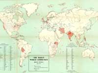
| Map #1: | Localities where Bahá'ís live (world, 1932)
Paper map measures 47 cm high x 63 cm wide
© C. S. Hammond Co., New York
Online at bahai-library.com/map_localities_world_1932. |
 |
| Bahá'í World Volume VI: 1934-1936 |
| Map #1: | Bahá'í Centers in Iran (1936)
Paper map measures 35.7 cm high x 44 cm wide
© Rand McNally & Company
Online at bahai-library.com/map_centres_iran_1936. |
 |
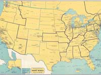
| Map #2: | Localities where Bahá'ís live (United States, 1935). Map also shows Bahá'í properties in the United States.
Paper map measures 36 cm high x 53 cm wide
Copyright: Rand McNally & Company
Online at map_localities_america_1935. |
 |
| Bahá'í World Volume VIII: 1938-1940 (Bahá'í World, Bahá'í localities) |
| Map #1: | Teaching regions of the United States and Canada - "America's Spiritual Mission" (1938) - showing locations of Local Spiritual Assemblies, Groups, and isolated believers. Map includes Alaska, Hawaii Islands and Puerto Rico.
Paper map measures 51 cm high x 79 cm wide
Online at teaching_regions_america_1938. |
 |
| Map #2: | Localities where Bahá'ís live (world, 1938)
Paper map measures 47 cm high x 63 cm wide
Printed especially for The Bahá'í World, 1938-1940
© C. S. Hammond Co., New York
Online at bahai-library.com/map_localities_world_1938. |
 |
| Bahá'í World Volume IX: 1940-1944 |
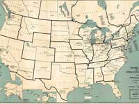
| Map #1: | Teaching regions of the United States and Canada (1940)
Map shows cities and townships in which individual Bahá'ís reside. The map also lists names of the cities and townships.
Map measures 63.5 cm high x 77 cm wide
© Rand McNally & Company
Online at teaching_regions_america_1940. |
 |
| Map #2: | Localities where Bahá'ís live (world, 1940)
Paper map measures 47 cm high x 63 cm wide
© C. S. Hammond Co., New York
Online at bahai-library.com/map_localities_world_1940. |
 |
| Bahá'í World Volume X: 1944-1946 |
| Map #1: | Localities where Bahá'ís live (world, 1944)
Paper map measures 47 cm high x 73 cm wide
© C. S. Hammond Co., New York
Online at bahai-library.com/map_localities_world_1944. |
 |
| Bahá'í World Volume XI: 1946-1950 |
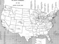
| Map #1: | Bahá'í community of the United States (1950)
Local Spiritual Assemblies and Groups and a list of all localities indicating whether it is an Assembly or a Group.
Paper map measures 63.5 cm high x 77 cm wide
State outline of map - US © Rand McNally & Company, Chicago
Supplementary material © 1952 by Bahá'í Publishing Committee
Online at map_localities_america_1950. |
 |
| Map #2: | Localities where Bahá'ís live (world, 1946)
© C. S. Hammond Co., New York
Paper map measures 47 cm high x 63 cm wide
Online at bahai-library.com/map_localities_world_1946. |
 |
| Bahá'í World Volume XII: 1950-1954 |
| Map #1: | Objectives and Tasks of Ten Year Spiritual Global Crusade of the Bahá'í World Faith
Drawn by Beatrice Ashton. Compiled from letters of the Guardian to the twelve National Spiritual Assemblies and their Annual Conventions of April and May 1953 and from Shoghi Effendi's statistical information and supplement on the Ten Year Teaching Plan.
Paper map measures 54.5 cm high x 88 cm wide
© National Spiritual Assembly of the Bahá'ís of the United States, 1954
Online at bahai-library.com/chart_tasks_10-year_crusade. |
 |
| Map #2: | Objectives and Tasks of Ten-Year Spiritual Global Crusade of the Bahá'í World Faith
Paper map measures 53 cm high x 99 cm wide
Map drawn by Shoghi Effendi and printed in Italy.
Online at bahai-library.com/shoghi-effendi_goals_crusade.
(See also Progress Bahá'í World Crusade 1953-1958, published separately.) |
 |
| Map #3: | Virgin countries and territories opened during the first year of the 10 Year Crusade 1953-1954
Paper map measures 49 cm high x 94 cm wide
© National Spiritual Assembly of the Bahá'ís of the United States, 1956
Online at map_pioneers_crusade_1956. |
 |
| Map #4: | Bahá'í Community of the United States (1954)
Map measures 60 cm high x 92 cm wide
© National Spiritual Assembly of the Bahá'ís of the United States, 1956
Online at map_localities_america_1954. |
 |
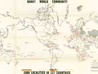
| Map #5: | Localities where Bahá'ís live (world, 1956) - detailed map: Map shows Countries where Bahá'ís reside, Countries having National Spiritual Assemblies; number of localities where Bahá'ís reside in leading Bahá'í communities throughout the world
Information published in red © by Bahá'í Publishing Committee.
Paper map measures 48 cm high x 78.5 wide
© C. S. Hammond Co., New York
Online at bahai-library.com/map_localities_world_1956a. |
 |
| Map #6: | Localities where Bahá'ís live (world, 1956) - simplified map
Paper map measures 58 cm high x 87 cm wide
© National Spiritual Assembly of the Bahá'ís of the United States, 1956
Online at bahai-library.com/map_localities_world_1956b. |
 |
| Bahá'í World Volume XIII: 1954-1963 |
| Map #1: | Progress Bahá'í World Crusade 1953-1958
Map drawn by Shoghi Effendi and printed in Italy.
Paper map measures 53 cm high x 98 cm wide
Online at bahai-library.com/progress_bahai_world_crusade. |
 |
| Map #2: | Localities where Bahá'ís live (world, Ridvan, April 1963):
Paper map measures 55 cm high x 87 cm wide
Online at bahai-library.com/map_localities_world_1963. |
 |
| Bahá'í World Volume XVII: 1976-1979 |
| Map #1: | Places named by ‘Abdu'l-Bahá in the Tablets of the Divine Plan
Bahá'í Publishing Trust, Wilmette, Illinois. Map designed by John Walbridge.
Paper map measures 60 cm high x 93 cm wide
© 1977 by the National Spiritual Assembly of the Bahá'ís of the United States
Online at map_places_named_tdp. |
 |
| Bahá'í World Volume XX: 1986-1992 |
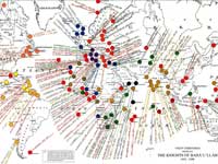
| Map #1: | Virgin Territories opened by The Knights of Bahá'u'lláh, 1953-1990
Map in color, whereas the earlier listing of countries opened (1953-54) is in black and white.
Map printed in Italy.
Paper map measures 44.5 cm high x 84 cm wide
Online at bahai-library.com/virgin_territories_knights_bahaullah. |
 |
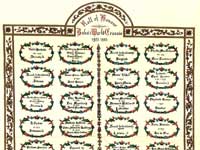
| Chart #1: | Roll of Honor Bahá'í World Crusade 1953-1963
Paper map measures 45.5 cm high x 84 cm wide
Online at bahai-library.com/roll_honor_knights_bahaullah.
(See also Progress Bahá'í World Crusade 1953-1958.) |
 |